Surveying
Diverse measurements
For which surveying services can you turn to KEN infra?
With our experienced surveyors we provide the gathering of data in the broadest sense of the word. We collect data on height, profile, subsidence and topography, and then organize and analyze.
We provide topographic measurements for terrain layouts in the industry and also for the large scale topography (BGT) that governments are obligated to work with. We map out areas and measure them accurately for new construction purposes. We keep a close eye on deformations in existing constructions, installations, pipelines, equipment or buildings, also through 3D scanning and continuous monitoring. So that you can quickly notice an inclination or subsidence.
In addition, we perform inventory projects of all outdoor elements. Such as signs, pavement and trees. Our draftsmen process the collected data in to a two-dimensional or three-dimensional (as-built) drawing and, if necessary, add fieldwork and measurement reports.
Advanced equipment
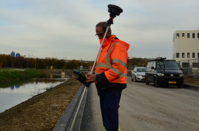
We use the most advanced measuring equipment for our work. Such as calibrated level instruments, total and one-man stations, 3D laser scanners and GPS equipment. All from the Leica brand. For the inventory of outdoor elements, we use a pen computer with GeoVisia.
The gathered data can lead to civil engineering. We will gladly solve these issues for you with our experienced civil engineers. Also, we carry out small excavation work to make test slots and even carry out small repair work on underground piping.


Contact
Would you like to know more about KEN group and what they can do for your company? Feel free to contact us.